
ABSALAN / WILDFIRE-SENTINEL
Wildfires Guard: Protecting Firefighters’ Lives and Preventing Billions in Wildfire Losses
ABSALAN Wildfire Sentinel: an AI surveillance network of tower, tree-top and drone sensors that detects wildfires at ignition and gives suppression teams a plan to contain them before they grow.
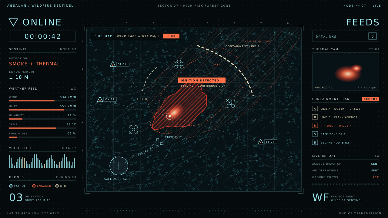
PROJECT WF / WILDFIRE SURVEILLANCE AND EARLY DETECTION
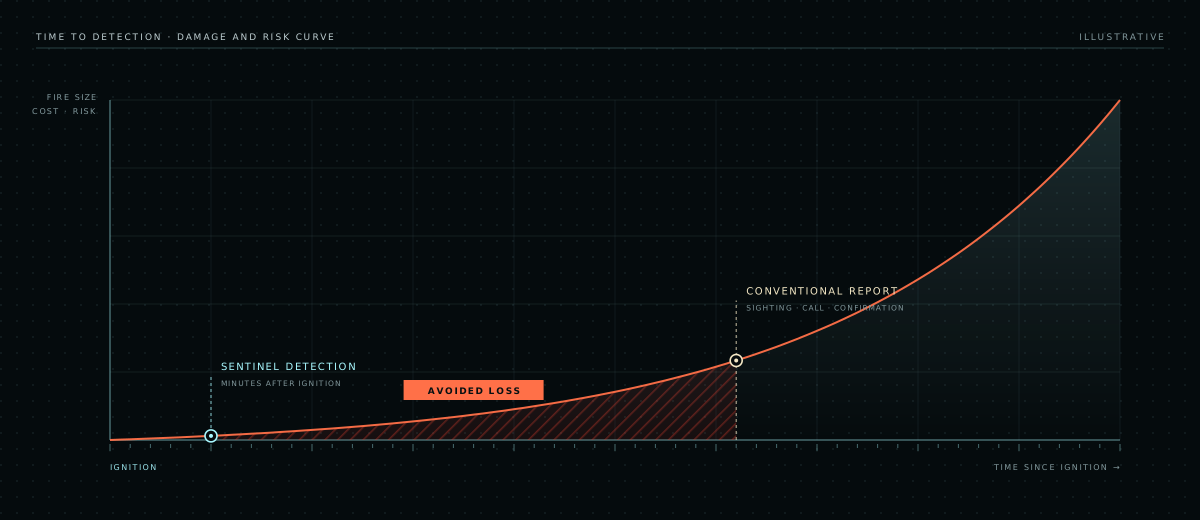
Wildfires are won or lost in the first minutes. A fire found while it is still the size of a campfire can be put out by a small crew. Found an hour later, the same fire may already be running through the canopy and throwing embers far ahead of itself. By then firefighters are fighting it on the fire's terms.
ABSALAN Wildfire Sentinel is a surveillance and early-detection system for forests and high-risk landscapes, the places where wildfires start. Sensor units on towers and tree tops watch for smoke, heat and changing weather around the clock. When a fire starts, the system's super-intelligence confirms it, maps it, predicts where it will spread, and sends wildfire suppression agencies a containment plan they can act on. Meanwhile, AI-controlled drones fly to the scene to keep that picture live.
Our goal is simple: bring every firefighter home, and stop wildfires before they become disasters that cost communities billions.
Every minute without an alert costs lives and money
LIVES
Firefighters pay for late detection
Firefighters face the greatest danger when a fire does something they could not see coming: a sudden wind shift, a run up a slope, or a spot fire igniting behind the line. Crews sent to a fire that is already established have less information, less time and fewer safe options. Earlier detection and better intelligence mean smaller fires, shorter operations and safer decisions.
ECONOMY
Damage grows with every hour a fire burns
Every hour a wildfire burns unchecked multiplies the cost: larger suppression operations, destroyed homes and businesses, damaged power lines and roads, lost timber and watersheds, closed tourism, insurance losses, and the health toll of smoke. In severe seasons the total runs into the tens of billions of dollars. Most of that loss starts as a fire that was found too late.
Eyes on the forest, from the tree tops to the sky
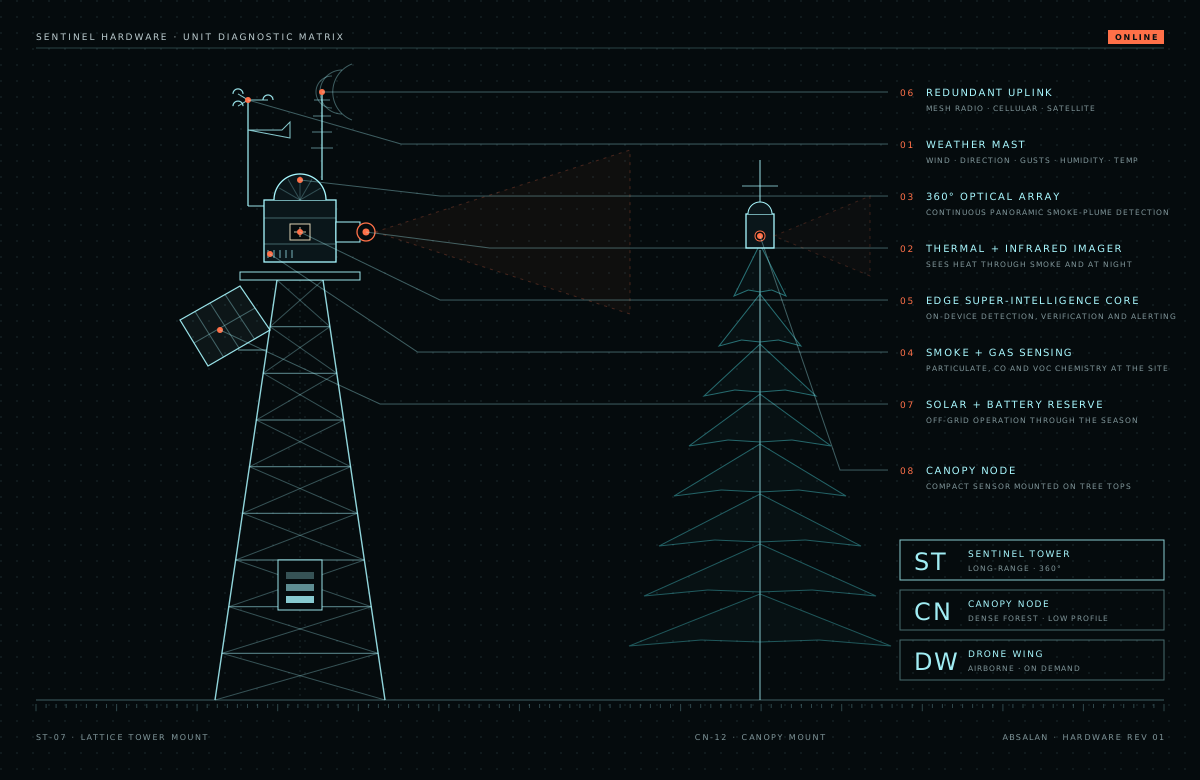
Wildfire Sentinel combines three sensing layers into a single network. Each layer covers the blind spots of the others, so a fire is seen from the ground, from the canopy and from the air.
ST
Sentinel towers
Long-range units mounted on towers and ridge-top masts. A 360° optical array and a thermal-infrared imager scan the landscape continuously for smoke plumes and heat signatures, day and night. An onboard weather station measures wind speed and direction, gusts, humidity and temperature.
CN
Canopy nodes
Compact sensors installed at the tops of trees in dense forest, where views from a tower are blocked. They detect smoke particles and combustion gases at the source and report the local microclimate, catching fires that start out of sight.
DW
Drone wing
AI-controlled drones based in the protected area. They patrol high-risk zones and are dispatched automatically to every alert to confirm the fire from the air, map its edge through smoke, and stream live data to the control center.
- Edge super-intelligence core. Every unit analyses its own sensor data and cross-checks it with its neighbours, so only real fires trigger an alert.
- Off-grid power. Solar panels with battery reserve keep units running through the fire season in remote terrain.
- Redundant communications. Mesh radio, cellular and satellite links keep alerts flowing even when one network fails.
An accurate map of the fire, and a plan to contain it
Detecting a fire is only the beginning. The Wildfire Sentinel super-intelligence combines live sensor and drone data with weather data and an understanding of how wind behaves over the terrain. From that it draws an accurate map of the fire as it is now, forecasts where it will be in thirty minutes, one hour and three hours, and works out the best way to contain it.
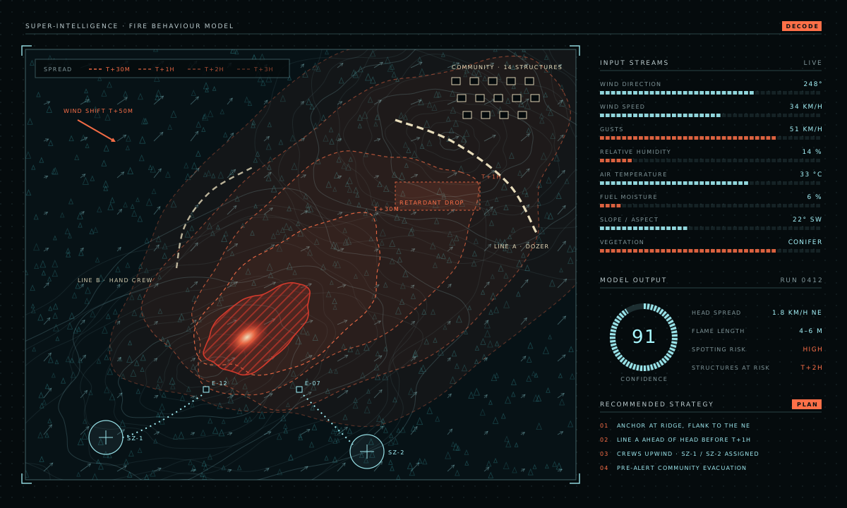
- Wind direction, speed and gusts, measured at every unit
- How wind behaves over the terrain: channelling in valleys, uphill runs and shifts
- Weather data and forecasts: temperature, humidity, approaching fronts
- Fuel moisture and vegetation type
- Terrain slope and aspect
- Thermal and visual imagery from towers, canopy nodes and drones
- Live fire map: the exact perimeter, the head of the fire and its intensity
- Spread forecast: where the fire will be at 30 minutes, 1 hour and 3 hours
- Containment plan: where to anchor, where to build lines, where aircraft should drop
- Crew safety: safe zones, escape routes and warnings of wind shifts
- Community protection: structures at risk and evacuation triggers
From the first wisp of smoke to a fire under control
- STEP 01
Detect
Towers and canopy nodes pick up smoke, heat or combustion gases at the moment of ignition.
- STEP 02
Verify
The edge intelligence cross-checks sensors while the nearest drone launches to confirm the fire from the air.
- STEP 03
Map
The fire's exact location and perimeter are plotted on a live map shared with responders.
- STEP 04
Predict
Weather, wind behaviour, fuel and terrain models project where and how fast the fire will spread.
- STEP 05
Plan
The system recommends a containment strategy, the resources to send, safe zones and escape routes.
- STEP 06
Notify
Suppression agencies, air operations and crews receive the alert, the map and the plan together.
- STEP 07
Track
Drones and sensors keep the picture live, and the plan updates as conditions change.
AI-controlled drones that see what crews cannot
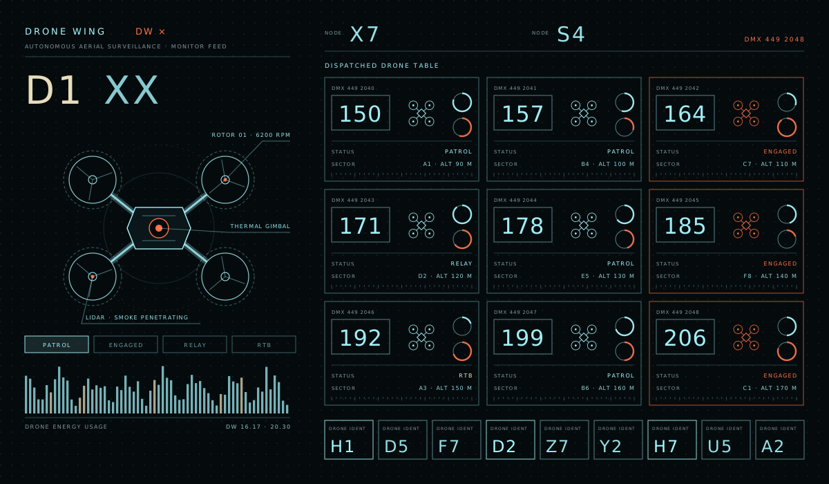
Smoke hides fires from the ground, and conditions change faster than any crew can scout. The Wildfire Sentinel drone wing gives incident commanders a live view from above. Drones are launched automatically when a sensor raises an alert and fly to the fire on their own. They then work as a coordinated team, sending everything they see back to the control center for analysis and live reporting.
- Thermal mapping of the fire's edge through smoke and at night
- Spot-fire detection ahead of the main front, before new fires grow
- Live video and data streamed to the control center
- Coordinated flight: drones map, relay communications and rotate to recharge so coverage never drops
Built around the people on the fire line
01
Wind-shift warnings
The model watches for changes in wind and weather that can turn a fire toward crews, and warns them before it happens.
02
Safe zones and escape routes
Every plan names safe zones and the routes to reach them, updated as the fire moves.
03
Spot-fire alerts
Drones and sensors flag new ignitions caused by embers, including behind the line.
04
One shared picture
Commanders, air operations and crews work from the same live map instead of partial radio reports.
The most valuable resource on any wildfire is the crew. Every minute of warning we give them is a minute they can use to stay safe.
Fires stopped early cost a fraction to fight
The cheapest wildfire is the one that never grows. By finding fires at ignition and sending responders a plan they can act on, Wildfire Sentinel aims to keep fires small, so operations stay short and losses stay low.
| Factor | Late detection | With Wildfire Sentinel |
|---|---|---|
| Fire at first response | Established and often spreading fast | Small, found at or near ignition |
| Resources required | Large multi-agency response and heavy aircraft | Initial attack crews with targeted air support |
| Firefighter exposure | Long, unpredictable operations | Short operations, planned with live intelligence |
| Homes and infrastructure | High risk to homes, power lines and roads | Protected by early containment |
| Recovery | Long, costly rebuilding and restoration | Limited burned area |
The benefits reach well beyond fire agencies: governments and municipalities, utility companies protecting power lines, forest owners and timber producers, insurers, and the communities living at the edge of the forest.
One live report for everyone on the incident
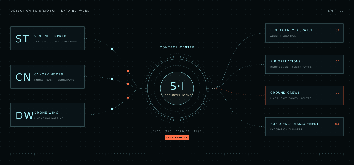
All sensor and drone data flows into the control center, where the super-intelligence fuses it, maps the fire, predicts its path and produces the containment plan. Each partner receives the information it needs: dispatch gets the alert and location, air operations get drop zones and flight paths, ground crews get lines, safe zones and routes, and emergency managers get evacuation triggers. The live report updates continuously until the fire is contained.
Designed for the places fires start
Where it is installed
- High-risk forests and national parks
- The wildland-urban interface, where homes meet the forest
- Power line and utility corridors
- Watersheds and protected landscapes
- Remote terrain with little or no network coverage
How a deployment works
- Wildfire risk assessment of the area
- Coverage design for towers, canopy nodes and drone bases
- Installation on towers, masts and tree tops
- Integration with agency dispatch and incident systems
- Seasonal operation, monitoring and support
PARTNER WITH US ON A PILOT DEPLOYMENT